Showing posts with label Ancient Mysteries. Show all posts

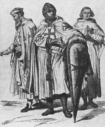
KNIGHTS OF TEMPLAR

Wednesday, May 5, 2010


With the advent of the dAvINCI cODE, there appears to be a swelling tide of interest relating to the question as to whether the medieval Knights Templar in fact possessed the Holy Grail. The answer to this is a very simple one: There is no doubt whatsoever that the Templars possessed the Holy Grail. The explanation behind this answer, unfortunately, remains somewhat complicated and, to a degree, very speculative. The key, as I have learned during the writing of The Labyrinth Of The Grail, is to constantly "look beyond" what appears at first to be the true answer. The simple reasoning is that why else would both the Church and State pursue the Templars to the far ends of the earth and torture them beyond compassion. Obviously, the accusations of blasmephy were only an excuse to justify their actions. It really doesn't take any skill to recognize that the inner circle of the Templars possessed something far more valuable than mere silver and gold - something that threatened the very being of the Church and State.

Founding of the Knights Templar
The First Crusade
(1) Call for a Holy War

"In medieval Europe "the ethics of the ruling class remained those of the Nibelungenlied and the Icelandic sagas. As late as the tenth century a heathen religious order called the Joms-Vikings appeared in Scandinavia, restricted to warriors of proven bravery who submitted to a harsh discipline, sleeping in barracks without women. Death in battle was their dearest ambition - to join Woden in Valhalla. The House-Carles who gave a grim an account of themselves at Hastings had been founded by King Sweyn Forkbeard, a former commander of these Jomsburg brethren, and many European noblemen had Scandinavian blood. The traditions of the northern war-band were very much alive in the twelfth century and the chansons de geste expressed the same pagan ideals: physical prowess, the joy of plunder and the duty of revenge."
- Desmond Seward, The Monks of War

The followers of the Warrior Cults of Northern Europe were feared for their frenzied ferocity in battle. Operating under a patchwork of warlords, they stood in the way of a pacified and united Europe operating under the Holy Roman Empire.

"The church tried desperately to stop the unending bloodshed. An early expedient was the 'Truce of God', specified days on which noblemen wore not to fight. The long-term policy was chivalry, an attempt to tame murderous instincts by providing a Christian ideal of the warrior; ultimately knighthood, originally a reputation for skill in battle, became almost a religious calling, hallowed by quasi-sacramental rites - vigils, weapon blessings, even vows of chastity. The code of the Germanic comitatus gave way to one of prayerful self-sacrifice, which exalted the protection of the defenseless.
- Desmond Seward, The Monks of War


Jerusalem - occupied by the Moslems since 638 - his appeal inspired extraordinary enthusiasm. Palestine's importance was heightened by the new appreciation of Christ's humanity; the scenes of the Passion were still pointed out at Jerusalem. That His City should belong to infidels was contrary to the law of God. And Holy War would provide a magnificent outlet for the destructive energy of barbarous nobles. "These saw the crusade as a summons by God to render military service and also as an opportunity to win new manors in the way they had been won in England and southern Italy. Shouts of 'Deus li volt' resounded throughout Europe and a great host of warlike pilgrims from all classes converged on the Holy Land singing the ancient, triumphant hymn 'Vexilla regis prodeunt'

The king dressed in a golden burnous and keffiyeh and gave audiences cross-legged on a carpet. Nobles wore shoes with up-turned points, turbans, and the silks, damasks muslins and cottons that were so different from the wool and furs of France. In the towns they lived in villas with courtyards, fountains and mosaic floors, reclining on divans, listening to Arab lutes and watching dancing girls. They ate sugar, rice, lemons and melons and washed with soap in tubs or sunken baths, while their women used cosmetics and glass mirrors, unknown in Europe. Merchants, grown accustomed to bazaars, veiled their wives, and professional wailers were seen at Christian funerals. Coins had Arabic inscriptions....The climate, with its short but stormy winters and long sweltering summers, and the new diseases, caused heavy mortality despite Arab medicine. The majority of the population was Moslem. Life, perpetually overshadowed by the sinister specters of death, torture or slavery, could only be endured by men of strong self-discipline.

In July 1099, the city of Jerusalem was attacked and stormed; the entire population murdered in a holocaust that lasted three days. 70,000 people died at the hands of the slaughterous heathens and the Knights Templar came into existence after this massAcre. Originally known as the Order of Poor Knights of the Temple of Solomon, they were a group of pious soldiers (many of whom were French) who decided to protect pilgrims on the dangerous roads between Jaffa (the place at which they landed in Palestine) and Jerusalem. This volunteer police force actually turned out to be comprised of noblemen like Hughes de Payens and Godefroi de Saint-Omer, men who wished to live a life of chastity. In return for providing protection to pilgrims, the church would offer them the remission of their sins.

There are many myths surrounding the Knights Templar, particularly relating to the Temple of Solomon and the Holy Grail. They did indeed inhabit the temple at one time, when King Baldwin offered them temporary residence, but beyond this is there much truth in the stories that surround them? Was there a Templar treasure, as so many authors claim? How did they manage to become the world's most wealthiest and powerful organisation and what caused their downfall? Wolfram von Eschenback wrote a poem called Parzifal which related the tale of the Holy Grail and of the Knights Templar. At the time, in 1220, the Templars were still around and were probably a famous group of men and Eschenback was trying to tell us that they guarded the precious object. Indeed, if they had guarded pilgrims travelling to the Holy City, why shouldn't they take it upon themselves to look after the grail as well.


By 1314 the Templars had transformed themselves into a body of men who were loathed by the church and certainly not admired for their heroic actions. On 18 March, Jacques Molay, the last Grand Master of the Order, Godffroi de Charney, the head of the Order in Normandy, and a third man were burned to death in Paris. It was claimed that they were devil worshippers - a rumour which seems to be untrue and which was almost certainly created to accentuate the charges of heresey brought against them. The simple facts were that they owned large tracts of valuable land which other people wanted to get their hands on! The Pope dissolved their order and warned that anyone thinking of joining would be excommunicated and charged as a heretic.

The "Rubant Document" claims that the Templars were very advanced for their time, thanks to secret knowledge they had obtained from books. Somehow, the Knights had managed to find a sort of "complete and absolute knowledge", a secret wisdom that was only known to the initiated. Raoul de Presle, a lawyer from the time, said that there was a strict secret held within the Order, the nature of which was so sensational that men would prefer to have their heads chopped off rather than divulge it! What on earth was this secret? Jacques de Molay had told the Inquisition just before his death that he would like to tell them "certain things" but they weren't authorised to hear them. Did this involve the secret doctrine of the Templars, something that might threaten the very foundations of normal Christianity, or did it merely involve the guarding of an object?
When the Knights Templar were founded in 1118-1119 in Jerusalem, it was a 'poor order' whose primary function was the protection of pilgrims along the main roads between the coast at Jaffa and the inland city of Jerusalem. But an important transformation took place when this nascent Order came under the patronage of St Bernard of Clairvaux, nephew of André de Montbard, one of the founding group of the Templars. Until his conversion at the age of twenty, St Bernard himself had been destined for a knightly career, and when he came to patronize the Knights Templar that Order was imbued with the ideals and convictions of the knightly class of Burgundy.


It was Hugues of Champagne who donated the site of Clairvaux to Bernard, where he built his abbey and from whence he expanded his 'empire'. He became the official 'sponsor' of the Templars, and it was his influence that ensured papal recognition at the Council at Troyes, this being the capital of Hughes' land....It was a disciple of Bernard's, Pope Innocent II, (formerly a monk at Clairvaux) who freed the Templars from all allegiance to anyone except the Pope himself In 1128, Bernard of Clairvaux "was just twenty-eight years old when the Council of Troyes asked him to help create a Rule for the Templars. He did more than that. He became their most vocal champion, urging that they be supported with gifts of land and money and exhorting men of good family to cast off their sinful lives and take up the sword and the cross as Templar Knights

St Bernard, who took a strong liking to Hughes, recognized a means of channeling the feudal nobility's surplus energy which would convert 'criminals and godless, robbers, murderers and adulterers'. He promised Hughes that he would compile a rule and find recruits. 'They can fight the battle of the Lord and indeed be soldiers of Christ'. Military Christianity had found it real creator Bernard urged young men to take up the Templar sword, comparing the Templar's holy way of life, so pleasing to God, to the degenerate ways of the secular knights, whose lives were dedicated to vanity, adultery, looting, and stealing, with many sins to atone for. The dedication to Christ, to a life of chastity and prayer, to a life that might be sacrificed in battle against unbelievers, was enough penance to atone for any sin or any number of sins. On that basis, Bernard appeared to sceleratos et impius, raptores et homicidas, adulteros, 'the wicked and the ungodly, rapists and murderers, adulterers', to save their own souls by enlisting as Kings of the Temple. That guaranteed absolution was also a way out for those suffering under decrees of excommunication. The taking of the Templar oath would evidence submission to the Church, and the supreme penance of a lifetime at war for the True Cross would satisfy God's requirement for punishment of the contrite.

The warriors are gentler than lambs and fiercer than lions, wedding the mildness of the monk with the valour of the knight, so that it is difficult to decide which to call them: men who adorn the Temple of Solomon with weapons instead of gems, with shields instead of crowns of gold, with saddles and bridles instead of candelabra: eager for victory -- not fame; for battle not for pomp; who abhor wasteful speech, unnecessary action, unmeasured laughter, gossip and chatter, as they despise all vain things: who, in spite of their being many, live in one house according to one rule, with one soul and one heart Another pools of recruits was provided by the poor knights who lacked the funds to acquire horses, armor, and weapons. All of those things would be given to them upon their entry, along with personal attendants and servants. They were certain of adequate food and a place in which to live. Their self-respect, no matter how low it might have sunk, would be instantly restored....(A heavy war-horse cost roughly the equivalent of four hundred days' pay for a free laborer).

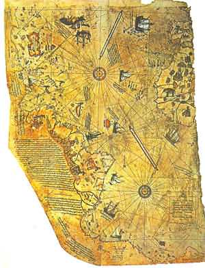
Piri Reiss Map


In 1929, a group of historians found an amazing map drawn on a gazelle skin. Research showed that it was a genuine document drawn in 1513 by Piri Reis, a famous admiral of the Turkish fleet in the sixteenth century. His passion was cartography. His high rank within the Turkish navy allowed him to have a privileged access to the Imperial Library of Constantinople.

The Turkish admiral admits in a series of notes on the map that he compiled and copied the data from a large number of source maps, some of which dated back to the fourth century BC or earlier. CONTROVERSY
The Piri Reis map shows the western coast of Africa, the eastern coast of South America, and the northern coast of Antarctica. The northern coastline of Antarctica is perfectly detailed. The most puzzling however is not so much how Piri Reis managed to draw such an accurate map of the Antarctic region 300 years before it was discovered, but that the map shows the coastline under the ice. Geological evidence confirms that the latest date Queen Maud Land could have been charted in an ice-free state is 4000 BC.

On 6th July 1960 the U. S. Air Force responded to Prof. Charles H. Hapgood of Keene College, specifically to his request for an evaluation of the ancient Piri Reis Map:

6, July, 1960
Subject: Admiral Piri Reis Map
TO: Prof. Charles H. Hapgood
Keene College
Keene, New Hampshire


Dear Professor Hapgood,
Your request of evaluation of certain unusual features of the Piri Reis map of 1513 by this organization has been reviewed. The claim that the lower part of the map portrays the Princess Martha Coast of Queen Maud Land, Antarctic, and the Palmer Peninsular, is reasonable. We find that this is the most logical and in all probability the correct interpretation of the map. The geographical detail shown in the lower part of the map agrees very remarkably with the results of the seismic profile made across the top of the ice-cap by the Swedish-British Antarctic Expedition of 1949.
This indicates the coastline had been mapped before it was covered by the ice-cap. The ice-cap in this region is now about a mile thick. We have no idea how the data on this map can be reconciled with the supposed state of geographical knowledge in 1513.
Harold Z. Ohlmeyer Lt. Colonel, USAF Commander

The official science has been saying all along that the ice-cap which covers the Antarctic is million years old. The Piri Reis map shows that the northern part of that continent has been mapped before the ice did cover it. That should make think it has been mapped million years ago, but that's impossible since mankind did not exist at that time.

Further and more accurate studies have proven that the last period of ice-free condition in the Antarctic ended about 6000 years ago. There are still doubts about the beginning of this ice-free period, which has been put by different researchers everything between year 13000 and 9000 BC. The question is: Who mapped the Queen Maud Land of Antarctic 6000 years ago? Which unknown civilization had the technology or the need to do that? It is well-known that the first civilization, according to the traditional history, developed in the mid-east around year 3000 BC, soon to be followed within a millennium by the Indus valley and the Chinese ones. So, accordingly, none of the known civilizations could have done such a job. Who was here 4000 years BC, being able to do things that NOW are possible with the modern technologies?

All through the Middle Ages were circulating a number of sailing charts called "portolani", which were accurate maps of the most common sailing routes, showing coastlines, harbors, straits, bays, etc. Most of those portolani focused on the Mediterranean and the Aegean seas, and other known routes, just as the sailing book which Piri Reis himself had written. But a few reported of still unknown lands, and were circulating among few sailors who seemingly kept their knowledge about those special maps as hidden as they could. Columbus is supposed to have been one of those who knew these special sailing charts.

To draw his map, Piri Reis used several different sources, collected here and there along his journeys. He himself has written notes on the map that give us a picture of the work he had been doing on the map. He says he had been not responsible for the original surveying and cartography. His role was merely that of a compiler who used a large number of source-maps. He says then that some of the source-maps had been drawn by contemporary sailors, while others were instead charts of great antiquity, dating back up to the 4th century BC or earlier.

Dr. Charles Hapgood, in his book Maps of the Ancient Sea Kings (Turnstone books, London 1979, preface), said that: It appears that accurate information has been passed down from people to people. It appears that the charts must have originated with a people unknown and they were passed on, perhaps by the Minoans and the Phoenicians, who were, for a thousand years and more, the greatest sailors of the ancient world. We have evidence that they were collected and studied in the great library of Alexandria (Egypt) and the compilations of them were made by the geographers who worked there. Piri Reis had probably come into possession of charts once located in the Library of Alexandria, the well-known most important library of the ancient times. According to Hapgood's reconstruction, copies of these documents and some of the original source charts were transferred to other centers of learning, and among them to Constantinople. Then in 1204, year of the fourth crusade, when the Venetians entered Constantinople, those maps begun to circulate among the European sailors.

Most of these maps - Hapgood goes on - were of the Mediterranean and the Black sea. But maps of other areas survived. These included maps of the Americas and maps of the Arctic and Antarctic Oceans. It becomes clear that the ancient voyagers travelled from pole to pole. Unbelievable as it may appear, the evidence nevertheless indicates that some ancient people explored Antarctic when its coasts were free of ice. It is clear too, that they had an instrument of navigation for accurately determining the longitudes that was far superior to anything possessed by the peoples of ancient, medieval or modern times until the second half of the 18th century. [...] This evidence of a lost technology will support and give credence to many of the other hypothesis that have been brought forward of a lost civilization in remote times. Scholars have been able to dismiss most of those evidences as mere myth, but here we have evidence that cannot be dismissed. The evidence requires that all the other evidences that have been brought forward in the past should be re-examined with an open mind." (Ibid.)

In 1953, a Turkish naval officer sent the Piri Reis map to the U.S. Navy Hydrographic Bureau. To evaluate it, M.I. Walters, the Chief Engineer of the Bureau, called for help Arlington H. Mallery, an authority on ancient maps, who had previously worked with him. After a long study, Mallery discovered the projection method used. To check out the accuracy of the map, he made a grid and transferred the Piri Reis map onto a globe: the map was totally accurate. He stated that the only way to draw map of such accuracy was the aerial surveying: but who, 6000 years ago, could have used airplanes to map the earth?? The Hydrographic Office couldn't believe what they saw: they were even able to correct some errors in the present days maps!! The precision on determining the longitudinal coordinates, on the other hand, shows that to draw the map it was necessary to use the spheroid trigonometry, a process supposedly not know until the middle of 18th century.

Hapgood has proved that the Piri Re'is map is plotted out in plane geometry, containing latitudes and longitudes at right angles in a traditional "gid"; yet it is obviously copied from an earlier map that was projected using spherical trigonometry! Not only did the early map makers know that the Earth was round, but they had knowledge of its true circumference to within 50 miles! Hapggod had sent his collection of ancient maps (we will see the Piri reis map was not the only one...) to Richard Strachan, at the Massachusetts Institute of Technology. Hapggod wanted to know exactly the mathematical level needed in order to draw the original source maps. Strachan answered in 1965, saying that the level had to be very high. In fact Strachan said that in order to draw such maps, the authors had to know about the spheroid trigonometry, the curvature of the earth, methods of projection; knowledge that is of a very high level. The way the Piri Reis map shows the Queen Maud land, its coastlines, its rivers, mountain ranges, plateaus, deserts, bays, has been confirmed by a British-Swedish expedition to Antarctic ( as said by Olhmeyer in his letter to Hapggod); the researchers, using sonar and seismic soundings, indicated that those bays and rivers etc, were underneath the ice-cap, which was about one mile thick.

Charles Hapggod, in 1953, wrote a book called "Earth's shifting crust: a key to some basic problems of earth science", where he made up a theory to explain how Antarctic had been ice-free until year 4000 BC. (visit the Bibliography ) The theory summing up is as follows: The reason Antarctic was ice-free, and therefor much warmer, it is to be found in the fact that, at one time, its location wasn't the south pole. It was located approximately 2000 miles further north. Hapgood says this "would have put it outside the Antarctic Circle in a temperate or cold temperate climate".

Read more information about Pole Shifting. The reason why the continent moved down to its present location has to be found in a mechanism called "earth-crust-displacement". This mechanism, not to be confused with the plate-tectonics or the continental drift, is one whereby the lithosphere, the whole outer crust of the earth "may be displaced at times, moving over the soft inner body, much as the skin of an orange, if it were loose, might shift over the inner part of the orange all in one piece". (Charles Hapgood, "Maps of the ancient sea-kings", cited, visit the Bibliography for more info).

This theory was sent to Albert Einstein, which answered to Hapgood in very enthusiastic terms. Though geologists did not seem to accept Hapgood's theory, Einstein seemed to be as much open as Hapgood saying: "In a polar region there is a continual deposition of ice, which is not symmetrically distributed about the pole. The earth's rotation acts on these unsymmetrically deposited masses, and produces a centrifugal momentum that is transmitted to the rigid crust of the earth. The constantly increasing centrifugal momentum produced in this way will, when it has reached a certain point, produce a movement of the earth's crust over the rest of the earth's body...." (Einstein's foreword to "Earth's shifting crust" p.1)

Anyway, whether Hapgood's theory is correct, the mystery still thrills. The Piri Reis map is something which is not supposed to exist. I mean that by no means there was supposed to be anyone that far back in time able to draw a map of such precision; in fact the relative longitudinal coordinates are totally accurate, as stated by Official studies on the map that we saw above. And this is a demonstration of impossible technology: the first instrument to calculate the longitude in a approximately correct way has been invented in 1761 by the english John Harrison. Before there was no way to calculate the longitude in an acceptable way: there could be errors of hundreds kilometers.... And the Piri Reis map is just one of several which show supposedly unknown lands, impossible knowledge, precision which still today would surprise........

In fact Piri Reis himself admitted he based his map on way older charts; and those older charts had been used as sources by others who have drawn different maps still of great precision. Impressive is the "Dulcert's Portolano", year 1339, where the latitude of Europe and North Africa is perfect, and the longitudinal coordinates of the Mediterranean and of the Black sea are approximated of half degree. An even more amazing chart is the "Zeno's chart", year 1380. It shows a big area in the north, going up till the Greenland; Its precision is flabbergasting. "It's impossible" says Hapgood "that someone in the fourteenth century could have found the exact latitudes of these places, not to mention the precision of the longitudes..." Another amazing chart is the one drawn by the Turkish Hadji Ahmed, year 1559, in which he shows a land stripe, about 1600 Km. wide, that joins Alaska and Siberia. Such a natural bridge has been then covered by the water due to the end of the glacial period, which rose up the sea level.

Oronteus Fineus was another one who drew a map of incredible precision. He too represented the Antarctic with no ice-cap, year 1532. There are maps showing Greenland as two separated islands, as it was confirmed by a polar French expedition which found out that there is an ice cap quite thick joining what it is actually two islands.

As we saw, many charts in the ancient times pictured, we might say, all the earth geography. They seem to be pieces of a very ancient world wide map, drawn by unknown people who were able to use technology that we consider to be a conquer of the very modern times. When human beings were supposed to live in a primitive manner, someone "put on paper" the whole geography of the earth. And this common knowledge somehow fell into pieces, then gathered here and there by several people, who had lost though the knowledge, and just copied what they could find in libraries, bazaars, markets and about all kind of places.

Hapggod made a disclosure which amazingly lead further on this road: he found out a cartographic document copied by an older source carved on a rock column, China, year 1137. It showed the same high level of technology of the other western charts, the same grid method, the same use of spheroid trigonometry. It has so many common points with the western ones that it makes think more than reasonably, that there had to be a common source: could it be a lost civilization, maybe the same one which has been chased by thousands years so far?
 
Ellada. Citrus Pink Blogger Theme Design By LawnyDesignz Powered by Blogger